Landslide Hazard Assessment Tool
What is LHAT?
LHAT is a GIS-based tool for data-driven forecasting of landslide susceptibilities. LHAT relies on globally and publicly available data sources as input for the data model. The user can choose between three machine learning models: Support Vector, Logistic Regression and Random Forest. These models are auto-parameterised using GridSearch and scored based on accuracy. Currently, the data inputs are considered static. LHAT has the option to be integrated into a forecasting framework for Early Warning Systems, and can receive dynamic and near real-time inputs such as precipitation data, inferometric Synthetic Aperture Radar (InSAR) maps, etc..
Why use LHAT?
LHAT is a flexible tool that is capable of taking in both user-defined inputs ( for example, high-resolution LiDAR data) as well as keeping the option to rely on global and/or publicly available assets. LHAT was built with the GHIRAF Framework in mind. GHIRAF is a Globally-applicable High-resolution Integrated Risk Assessment Framework, allowing for provision of globally available data ( local when possible), rapid risk assessment and flexibility. Building LHAT in this manner allows its inputs to remain flexible, and enables inter-operability between other risk assessment tool (such as Delft-FIAT, RA2CE, Ri2de or Criticality tool).
LHAT has been tested on areas within Bangladesh and Jamaica thus far, with accuracies of more than 80%.
When should I use LHAT?
A main requirement of the LHAT tool is the need for historical occurrences of landslides in an area (in the form of coordinates). The sufficiency and representation of the landslide data, both in time and space, is a main determining factor on the accuracy of the output susceptibility map.
The final result of the LHAT tool is a map showing probabilities of landslide occurrences.
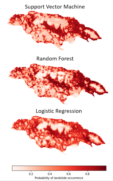
Fig. 1: Example results from each of the models